
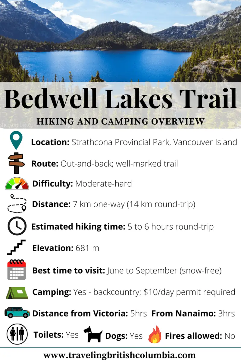
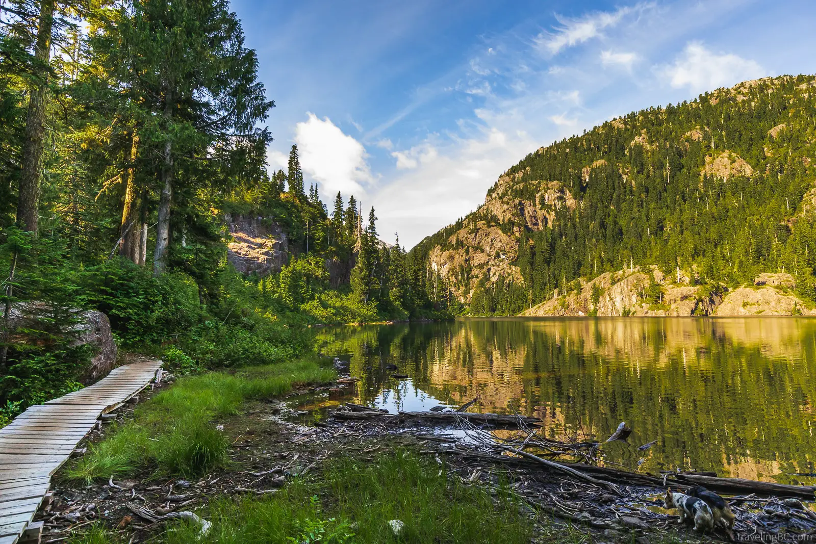
For a spectacular backcountry adventure, look no further than the Bedwell Lakes Trail in Strathcona Provincial Park, BC! This hiking trail takes you through an ancient forest up to a subalpine plateau, where you will find two magnificent lakes surrounded by breathtaking mountain vistas. There, you can camp at Baby Bedwell Lake and Bedwell Lake, two of the most beautiful lakes on Vancouver Island. Doesn’t that sound amazing?!
Only a few hours away from Victoria, Baby Bedwell and Bedwell Lake are perfect for a day hike or a weekend getaway! While the Bedwell Lakes Trail can be done in a single day, we highly recommend turning this adventure into an overnight camping trip to get the most out of your experience. You can camp right beside either lake, waking up with phenomenal views of the water and mountains! Also, you can extend your trip by hiking to Cream Lake or Little Jim Lake, two vibrant blue alpine lakes just past the Bedwell Lakes.
In this article, you will find everything that you need to know to hike and camp the Bedwell Lakes Trail, including a trail overview, gear list, when to visit, maps, and more!
Bedwell Lakes Trail Guide Overview
Where Is the Bedwell Lakes Trail?
The Bedwell Lakes Trail is in Strathcona Provincial Park, the largest protected area on Vancouver Island and BC’s oldest provincial park. Strathcona is located near Campbell River and Gold River in central Vancouver Island and is a fantastic place for outdoor adventures of all kinds.
Getting to the Bedwell Lakes trailhead is pretty straightforward, but you will need a vehicle (or at least a bike). There is no public transportation from Gold River or Campbell River.
Below is a map of the Bedwell Lakes. Click on the markers on the map to get directions to the Bedwell Lakes, or click here for directions to the trailhead. Alternatively, read on for a description of how to get to the Bedwell Lakes trailhead!
Baby Bedwell Lake, Strathcona Provincial Park, British Columbia, Canada
Bedwell Lakes Trailhead, Jim Mitchell Lake Road, Strathcona Provincial Park, British Columbia, Canada
Bedwell Lake, Strathcona Provincial Park, British Columbia, Canada
How to Get to the Bedwell Lakes Trail
To get to the Bedwell Lakes trailhead, you will take Highway 19 to Campbell River. Most of the island will have to access the trail by going through Campbell River.
In Campbell River, turn west onto Highway 28 and head towards Gold River. Don’t forget to fill up on gas because there are no gas stations between Campbell River and Gold River!
Follow the signs west for Gold River until you find a three-way intersection (46.5 km from Campbell River), with one route turning west to Gold River (Highway 28) and the other continuing straight to the south (Westmin aka Western Mines Road). You want to follow the southern route, on Westmin Road. If you are coming from Gold River, you would follow Highway 28 east until Westmin Road.
Along this road, you will be treated to beautiful views of Buttle Lake, a 23 km long lake at the Campbell River headwaters. Many visible stumps poke out from the water, leftover from a forest logged before the Strathcona Dam was built.
Follow the Westmin Road until you are at the south end of Buttle Lake, where you will get the best view of the picturesque Buttle Lake. It is definitely worth stopping to snap a few photos!
Immediately after you cross over the Thelwood Creek bridge (80km from Campbell River), you will turn left onto Jim Mitchell Lake Road, a gravel mining road leading to the trailhead. If you see the turn for Myra Falls, you have gone too far! There will be signs for the Bedwell Trail.
Check the signage at the start of the road to make sure there aren’t any current restrictions. The road is usually accessible through the summer. In winter, unplowed snow can make it difficult to get to the trailhead.
Continue on Jim Mitchell Lake Road until you find a three-way intersection (2.6 km down the road), where you will stay right. At the second intersection, follow the road left (the right side is marked as no public access).
From there, simply continue up the road until you find the parking lot! There is plenty of parking in the parking lot or along the sides of the road. You’ll always be able to find a spot, even on the busiest of weekends. Lock your vehicle and remove any valuables, as sometimes theft occurs in the parking lot.
The parking lot has an information board with current notices and conditions for the trail. Also, there is a map, an outhouse, and the permit collection vault.
Additionally, if you want to explore a bit more of the area, head past the Bedwell Lakes Trail parking lot and you will come across Jim Mitchell Lake, a small lake with a hydroelectric dam that powers the nearby mine.
Bedwell Lake Trailhead coordinates: 49.522127, -125.587217
Will My Vehicle Make It to the Bedwell Lakes Trailhead?
Most vehicles can make it up to the trailhead if you drive carefully. The first part of the road is well-maintained but the second half gets more bumpy, rocky, and steep. To avoid any issues, we recommend using a vehicle with high clearance. 4wd isn’t usually necessary during the summer. Road conditions vary so check the BC Parks website for updates on access.
If you feel uncomfortable with the road, park when the road starts getting rough and walk the rest. Jim Mitchell Road is only 7 km long, so you would only be adding 2-3 km onto your hike.
Hiking the Bedwell Lakes Trail
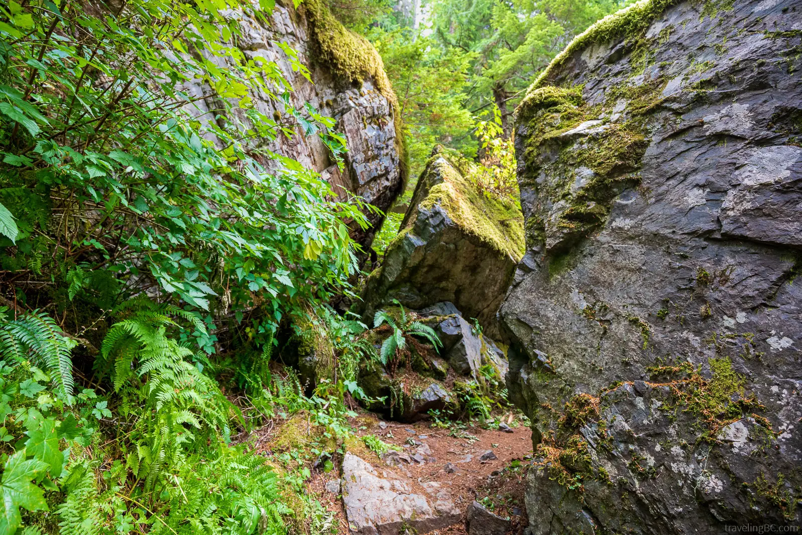
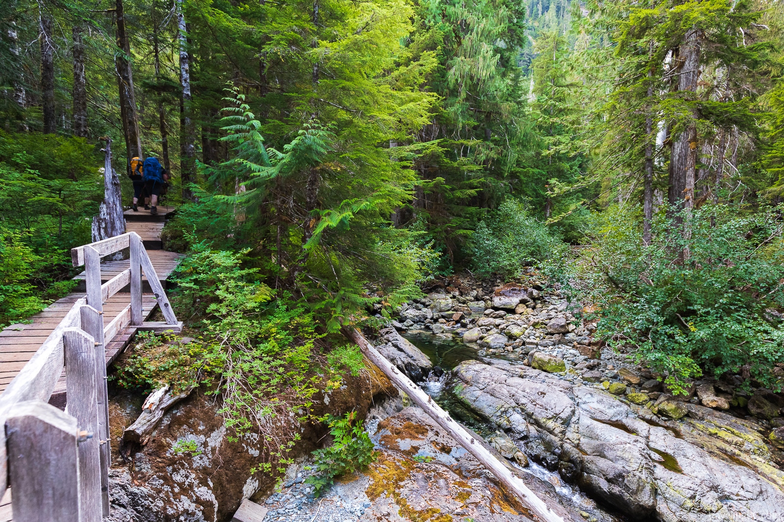
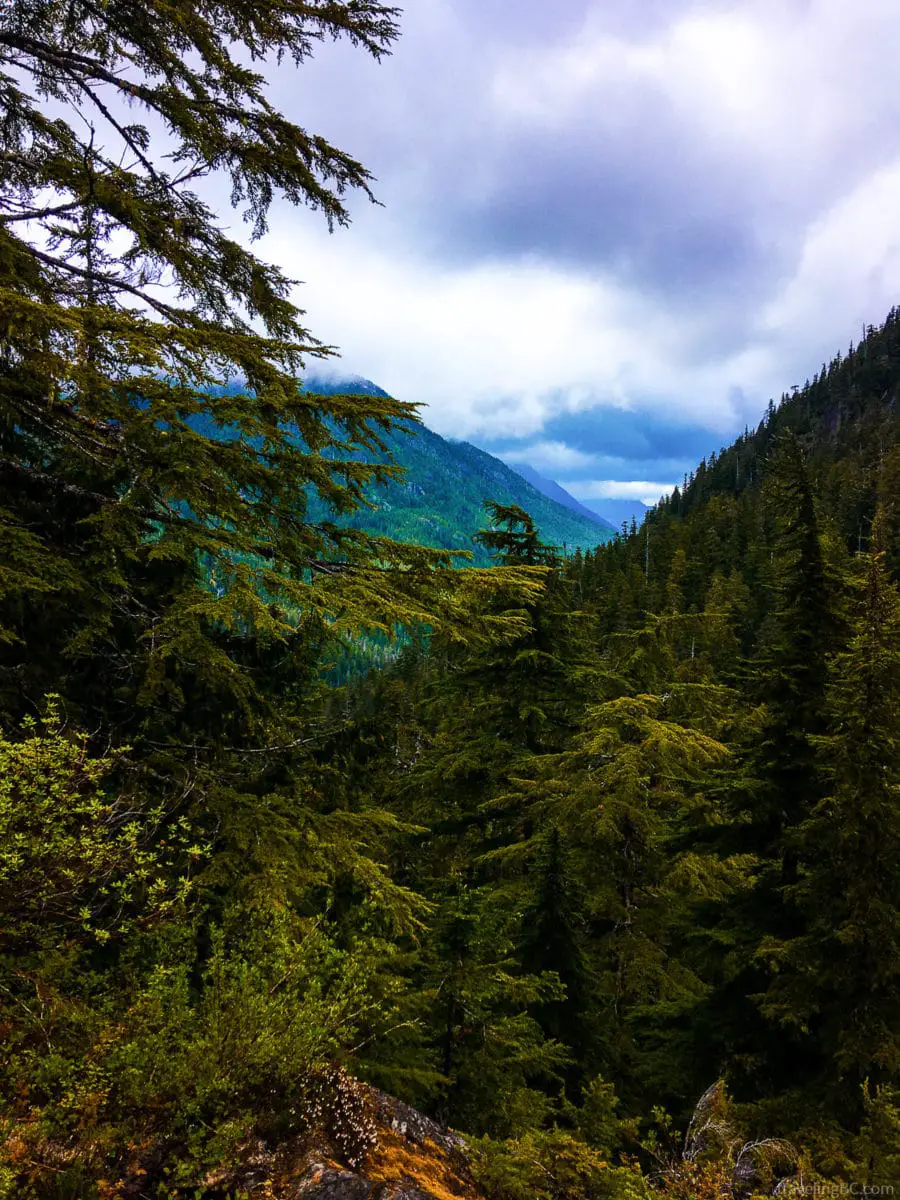
The Bedwell Lakes Trail is an out-and-back trail that is well marked, and easy to follow. The trail takes you through an old-growth forest, up steep terrain using switchbacks, past impressive rock walls, between massive boulders, over multiple wooden bridges crossing forest creeks, and through a subalpine plateau on boardwalks. You’ll get fantastic views of the forest and valley along the way before you come across the two beautiful Bedwell Lakes.
Total hike distance (round-trip): 14 km
Total estimated hiking time (round-trip): 5 to 7 hours
Bedwell Lakes Trail Difficulty
The Bedwell Lakes Trail is a moderate-hard trail, depending on your level of fitness. A significant portion of the hike is uphill on switchbacks, which gets quite exhausting if you are carrying camping gear.
You have to watch your footing along most of the trail. The trail has uneven ground, roots, and rocks. After heavy rains, the trail gets muddy and the wooden stairs get slippery.
Despite this, the trail is quite rewarding and is great for new backcountry campers. The trail is well-trafficked, easy to navigate (in summer), non-technical, and manageable as a single overnighter (or two!). Regardless of skill level, it is always important to bring a backcountry communication device, like a SPOT or inReach, in case of emergencies.
If you complete the trail in winter, snow will make it hard to find the path. Snow lasts late into the summer (into at least June) and can start early (around October). A good GPS (like a Garmin eTrex) is important to bring in winter, especially if you don’t know the area.
If there is snow, snowshoes are a must-have! Without snowshoes, you will do a lot of post-holing (falling knee- or waist-deep into snow) which is risky for leg injuries, exhausting, cold, and frustrating.
Map of the Bedwell Lakes Trail
Click here for a map of the trail!
Bedwell Lake Trail Description
To get to the trailhead, walk past the parking lot about 200m. The trailhead is marked by a tiny sign and is on the left-hand side (southeast) of the road, heading down into the forest.
The trail begins with an easy walk, heading into the valley bottom and a forest of old-growth trees. You will walk under and beside a few very large trees, giving you an appreciation of just how large these trees are!
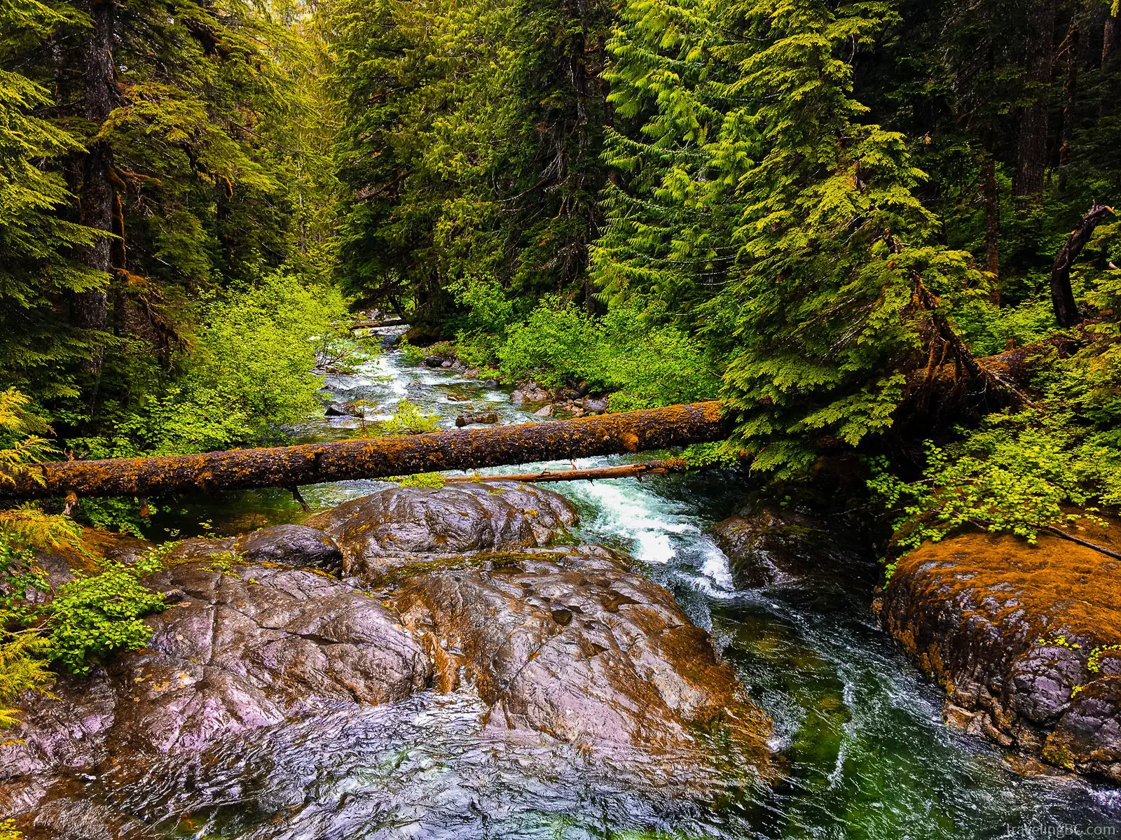
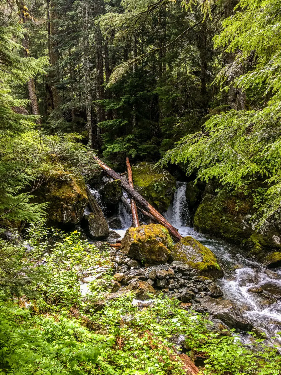
Shortly, you will come across a suspension bridge crossing Thelwood Creek. Depending on when you visit the trail, there may or may not be water. Soon after, there will be another bridge crossing the blue, clear water of Big Jim Creek. The trail gets more difficult after the bridges, taking you out of the valley through a series of switchbacks.
First, you will head up from the valley bottom on switchbacks and stairs for about 2 km. This part of the hike has amazing views of the forest. Keep your eye out for wild mushrooms!
After panting up this section of the trail, you’ll finally arrive at a flat section of the trail that lasts about 1 km. Enjoy this section because it won’t last long!
Once you cross a series of smaller wooden bridges, you will climb in elevation again, up more switchbacks and wooden stairs. There is a perfect spot to stop halfway up this part of the hike to admire the view of the valley (and catch your breath).
The uphill hike continues until you reach several green steel stairs, which take you up a steep portion of the trail. If you have a dog, they might need a boost!
The trail gets much easier after you reach the stairs, becoming mostly flat or downhill. Walk along the trail and boardwalks past some small subalpine ponds until you reach a three-way intersection with an information board. At the intersection, either head right to Baby Bedwell Lake, or left to continue to Bedwell Lake.
Baby Bedwell Lake
If you head right at the intersection, you will quickly arrive at Baby Bedwell Lake and its campground. Most of the tent pads are located on the rocky area near the lake. If you head right once you see the tent pads, you will find the bear cache and outhouse.
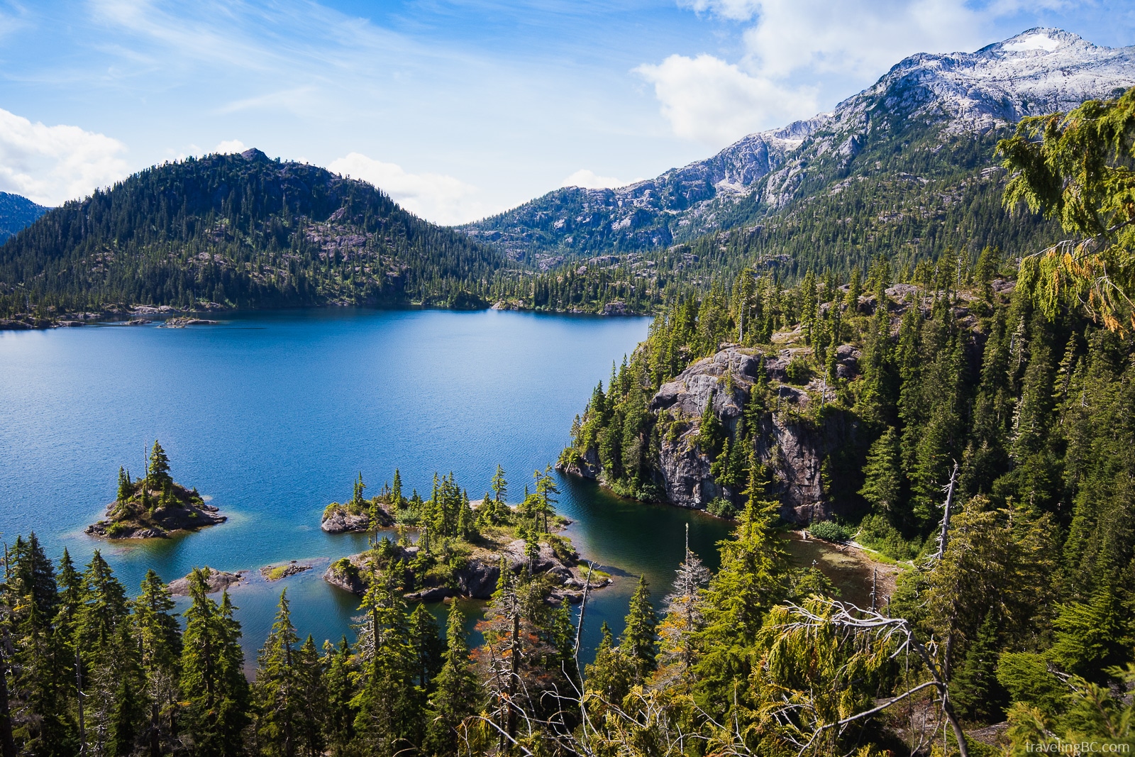
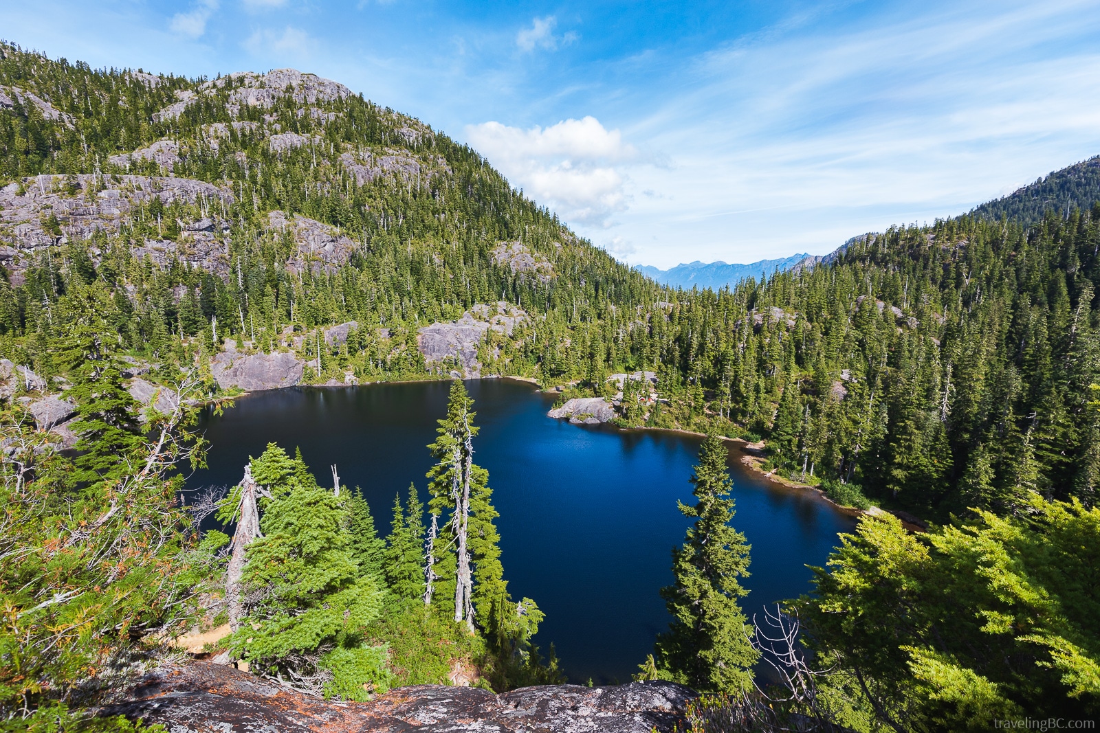
Baby Bedwell Lake is the perfect stop for a rest and refreshing swim before heading up to Bedwell Lake. It’s worth a stop, even if you plan on heading onwards. The lake is very beautiful and scenic, with Mount Tom Taylor in the background.
If you like swimming, the best place to get into the water is just past the tent pads on the rocks. Alternatively, there is a small rocky beach near the camping area where you can wade into the water or fill up your water bottle. The water in Baby Bedwell Lake is clean and cool, but still perfect for a swim on a warm day, even later in the year.
How Long Is the Hike to Baby Bedwell Lake?
Distance to Baby Bedwell Lake (one-way): 3.5 km
Total hiking distance to Baby Bedwell Lake (round-trip): 7 km
Estimated hiking time to Baby Bedwell Lake (one-way): 1.5 to 3 hours
Estimated time to Baby Bedwell Lake (round-trip): 1.5 to 3 hours
Elevation gain: 519 m
Bedwell Lake
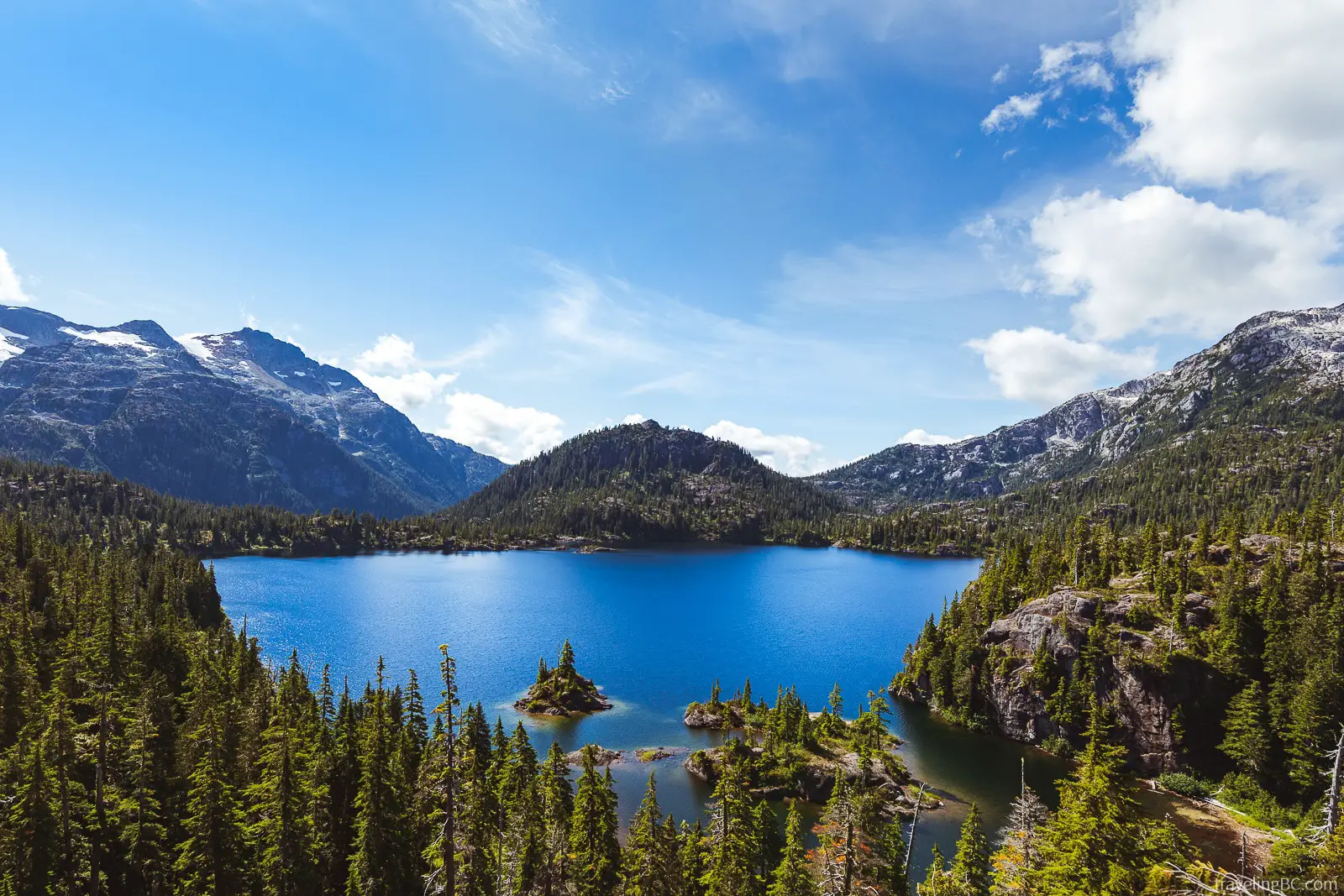
If you continue to Bedwell Lake, you will pass over a boardwalk beside Baby Bedwell. Then, you will head up a series of green steel stairs up to the Bedwell Lake viewpoint. This part of the hike is all uphill, but extremely worth the climb. Make sure you stop at this lookout as it has one of the best views of Bedwell Lake.
Follow the sign for Bedwell Lake down the hill to make your way to the Bedwell Lake campground. The path will head down towards the lake, over more wooden and green steel stairs. You’ll be treated to more amazing views of the lake along the way, and a great swim when you finally arrive!
Swimming in Bedwell Lake is chilly but fabulous! After hiking, it’s an amazing feeling to jump into the lake to cool down. If you like cliff jumping, there are even a few spots around the lake that are good. Nothing makes you feel more alive than swimming in a refreshing subalpine lake, surrounded by the backcountry wilderness. Afterward, you can dry off on the rocks in the sun!
How Long Is the Hike to Bedwell Lake?
Distance to Bedwell Lake (one-way): 7 km
Total distance for round-trip hike to Bedwell Lake: 14 km
Estimated hiking time to Bedwell Lake (one-way): 2.5 to 3 hours
Estimated time to Bedwell Lake (round-trip): 5 to 6 hours
Elevation gain: 681 m
Bedwell Lake to Cream Lake Hike
If you are up for more exploring, you can hike from Bedwell Lake to Cream Lake. Cream Lake is a stunning turquoise lake at the bottom of Mount Septimus, only 5km past Bedwell Lake. It’s worth hiking the extra distance – Cream Lake has unbeatable views of the mountain vistas and the lake itself is unquestionably beautiful. You will also hike by Little Jim Lake, a bright blue lake with stellar views.
The hike to Cream Lake takes you through colorful wildflowers, past alpine ponds, through fields of boulders, and opens up to mind-boggling views of the surrounding mountains. Look for Big Interior Mountain and Nine Peaks, two impressive mountains near the lake.
At Cream Lake, you will be rewarded with a chilly dip in a blue glacier lake and views of the jagged peak of Mount Septimus. You can even spot Della Falls, one of the tallest waterfalls in Canada, in the distance!
Cream Lake is much more remote-feeling than the Bedwell Lakes and less trafficked. The path is more difficult and hiking poles are recommended. While camping is allowed, there are no designated campsites near Cream Lake, so follow Leave No Trace camping etiquette if you camp in the area.
How Long Is the Hike to Cream Lake?
Distance to Cream Lake from Bedwell Lake (one-way): 5 km
Total distance for round-trip hike to Cream Lake from trailhead: 24 km
Estimated hiking time to Cream Lake from Bedwell Lake (one-way): 2.5 hours (5 hours round-trip)
Estimated time to Cream Lake from the trailhead (round-trip): 9 to 10 hours
Elevation gain: 1328 m
Bedwell Trail Camping Permit
You will need a backcountry permit if you plan on camping at the Bedwell Lakes or Cream Lake. Hiking day trips with no overnight camping do not require a permit. Also, you don’t need a permit if you do winter camping. You can click here to find a map showing the fee collection area for the Bedwell Lakes Trail.
The backcountry camping fee costs $10 per adult per night (16 years and older), or $5 per child per night (6 to 15 years old). Permits can be paid at the trailhead or online.
The permit collection vault at the trailhead is in the parking lot, near the trail signs. Simply fill out the permit form, put your cash in the envelope, rip off your copy of the permit (one to carry with you and one to display in your vehicle), place the permit envelope in the metal self-registration fee vault, and you’re good to go!
Alternatively, you can pre-pay for a permit up to two weeks in advance through the BC Parks Backcountry Permit Registration System. This registration system doesn’t reserve you a spot, but you won’t have to carry cash. The permit is not refundable so plan accordingly! If you do show up and there are no spots, you are allowed to camp for one night in a non-designated campsite, following “leave no trace” practices.
Keep your permit with you at all times! Park rangers will collect them along the trail, and you don’t want to be caught without one!
Camping and Day Hike Gear List for the Bedwell Lakes Trail
Coming soon!
Camping at the Bedwell Lakes

Camping is allowed at both of the Bedwell Lakes and is highly recommended to get the most out of your backcountry experience!
A camping trip to either lake will be unforgettable. You can spend the day swimming and relaxing by the lake. Later, watch the sunset paint the mountains in reds and oranges. And, if you stay up late enough, you can lay beside the lake under thousands of stars. If you are lucky, you might even spot a couple of shooting stars!
In the morning, you’ll wake up in a cloud of fog, with only glimpses of the lake, trees, and mountains. As you sip your morning coffee, you can watch the fog roll away in swirls to reveal the mountain peaks. It’s a magical feeling!
The Bedwell Lakes campgrounds have everything that you need to have a perfect camping trip, including tent pads, bear caches, and outhouses.
Bedwell Lake and Baby Bedwell Lake Tent Pads
There are lots of designated wooden tent platforms for you to choose from at both Baby Bedwell and Bedwell Lake. The tent pads are new, well made, decently flat, and have hooks on the sides for tying down your tent.
All of the tent pads are very scenic, no matter which one you choose. Most will have great views of the mountains or the lakes. All of the tent pads are located a short walk from the outhouse and bear cache.
Bear Caches on the Bedwell Lakes Trail
There are many bears in the area!
Each campground has a bear-proof food cache for storing any bear attractants, including food, cooking gear, and toiletries. The Baby Bedwell food cache is to the right of the outhouse, down a short path. You’ll find the Bedwell Lake food cache near the trail leading from Baby Bedwell Lake, at the start of the campsites. Keep a camp clean of any bear attractants (like food or toiletries), and store anything scented in the food caches.
You should always have bear spray with you (two cans are better than one!), which has a 98% effectiveness in deterring bear attacks. Carry bear spray everywhere you go (even to the outhouse!).
Toilets on the Bedwell Lakes Trail
Baby Bedwell Lake and Bedwell Lake each have an outhouse near the camping area. The Baby Bedwell Lake outhouse is near the bear cache, just down a short trail from the campsites. The Bedwell Lake outhouse is nearby the start of the trail to Little Jim Lake and Cream Lake.
Don’t forget to bring toilet paper and hand sanitizer! Usually, the outhouse has toilet paper, but this isn’t a guarantee. There is no supplied hand sanitizer.
The Bedwell Lake outhouse is a vermicomposting, conveyor belt (you’ll understand when you see it) outhouse which is more eco-friendly than traditional pit outhouses. The Baby Bedwell outhouse is currently being replaced by one of these newer outhouses.
Drinking Water on the Bedwell Lakes Trail
There is plenty of drinking water on the Bedwell Lakes Trail. You can get water from either the lakes or the nearby forest creeks. There are always a few creeks that are still running with water, even during the driest summer periods. However, we always start the hike with water in a water reservoir, just in case!
All of the water on the trail will need to be filtered or purified. If we are traveling with a group, our favorite water filter is the Platypus Gravity Works 4L filter system. This filter lets you filter up to 4L of water and gravity does all the work for you! For one or two people, we prefer a Sawyer Squeeze water filter, which is smaller and better for on-the-go filtering. Also, as a backup, we carry Aquatabs water purification tablets, which are lightweight and great for survival kits.
Are Campfires Allowed on the Bedwell Lakes Trail?
Unfortunately, no open campfires are allowed in Strathcona Provincial Park’s backcountry, due to the remoteness and fragileness of the alpine ecosystem. You can still use the flame from your cooking gear (like a Jetboil Cooking System) to prepare food.
Since you won’t be able to warm up near the fire, we recommend bringing warm clothes for the evening (like an Arc’teryx insulated jacket), tea or hot chocolate, and a good sleeping bag.
When to Visit the Bedwell Lakes
The best time of year to visit the Bedwell Lakes is from June to September when all of the snow has melted and the mountains are warmer. The trail is usually snow-free by the end of June or the start of July, until late September or October. Summer is the busiest time in the park, so ideally go on a weekday or arrive early on a Friday.
If you don’t mind the snow, you can hike and camp the Bedwell Lakes Trail year-round. If you camp during winter, make sure you are well prepared for the cold and snow. Unlike other parts of Vancouver Island, Strathcona Provincial Park gets a lot of snow!
Are Dogs Allowed on the Bedwell Lake Trail?
Yes! Dogs are allowed on the Bedwell Lake trail for both hiking and camping!
Your dog(s) must stay leashed and under control at all times, to respect the environment and the wildlife. Pack any dog waste bags out of the park, to protect the fragile ecosystem. If you cannot pick up your dog’s poop for some reason, follow Leave No Trace rules, and bury any waste in a 15 to 20 cm (6 to 8 inches) deep hole at least 70 m (220 feet) from campsites, trails, and water sources.
One benefit of hiking with your dog is you can split the load with them using a dog backpack! They can carry their food and any other dog essentials. The handle on the backpack is also useful for helping your pup up tough terrain or over streams.
Accommodations Nearby the Bedwell Lake Trail
Camping
Two BC Parks campgrounds are located near the Bedwell Lakes Trail: Ralph River Campground (20min from the trailhead) and Buttle Lake Campground (one hour away). Both are in beautiful locations and near many awesome hiking trails.
Hotels
There aren’t many hotels immediately nearby the Bedwell Lakes Trail, due to its remoteness. However, there are many great, cheap options for accommodations in Campbell River or Gold River, both about 1.5 hours from the trailhead.
Bedwell Lakes Itineraries
Day Hike
Hike to Bedwell Lake (7 km one-way), stopping at Baby Bedwell Lake and the Bedwell Lake viewpoint along the way. The Bedwell Lakes trail hike can be shortened by only going as far as Baby Bedwell (3.5 km one-way) or the viewpoint.
Two Days/One Night
Suggestion 1: On day 1, hike to Bedwell lake (7 km) and set up camp there. Enjoy swimming in Baby Bedwell on the way there. Optionally, hike to Little Jim Lake or Cream Lake (5 km one-way), if you want a longer trek. On day 2, hike back to the parking lot (7 km).
Suggestion 2: On day 1, hike in and set your tent up at Baby Bedwell Lake (3.5 km). Leave your stuff there and with a day pack, head to Bedwell Lake (3.5 km one-way) or Cream Lake (8.5 km one-way) for the afternoon. Return later to sleep at Baby Bedwell. Hike out on Day 2 (3.5 km).
Suggestion 3: On day 1, hike to Cream Lake (12 km) and set up camp there, enjoying the other lakes on the way. On day 2, hike back to the parking lot (12 km).
Three Days/Two Nights
Suggestion 1: Camp at Baby Bedwell Lake (3.5 km) the first night (Day 1). Hike to Bedwell Lake on Day 2, and camp there (3.5 km). Optionally, extend your hike by heading to Cream Lake (5 km) or Little Jim Lake for the day. On Day 3, return to the trailhead (7 km return).
Suggestion 2: Camp at Bedwell Lake (7 km) on the first night (Day 1). On Day 2, hike to and camp at Cream Lake (5 km). Hike out on Day 3 (12 km).
Suggestion 3: Camp at Baby Bedwell Lake (3.5 km) on Day 1. On Day 2, hike past Bedwell Lake to Cream Lake (8.5 km) and camp there for the night. On Day 3, hike out from Cream Lake to the trailhead (12 km).
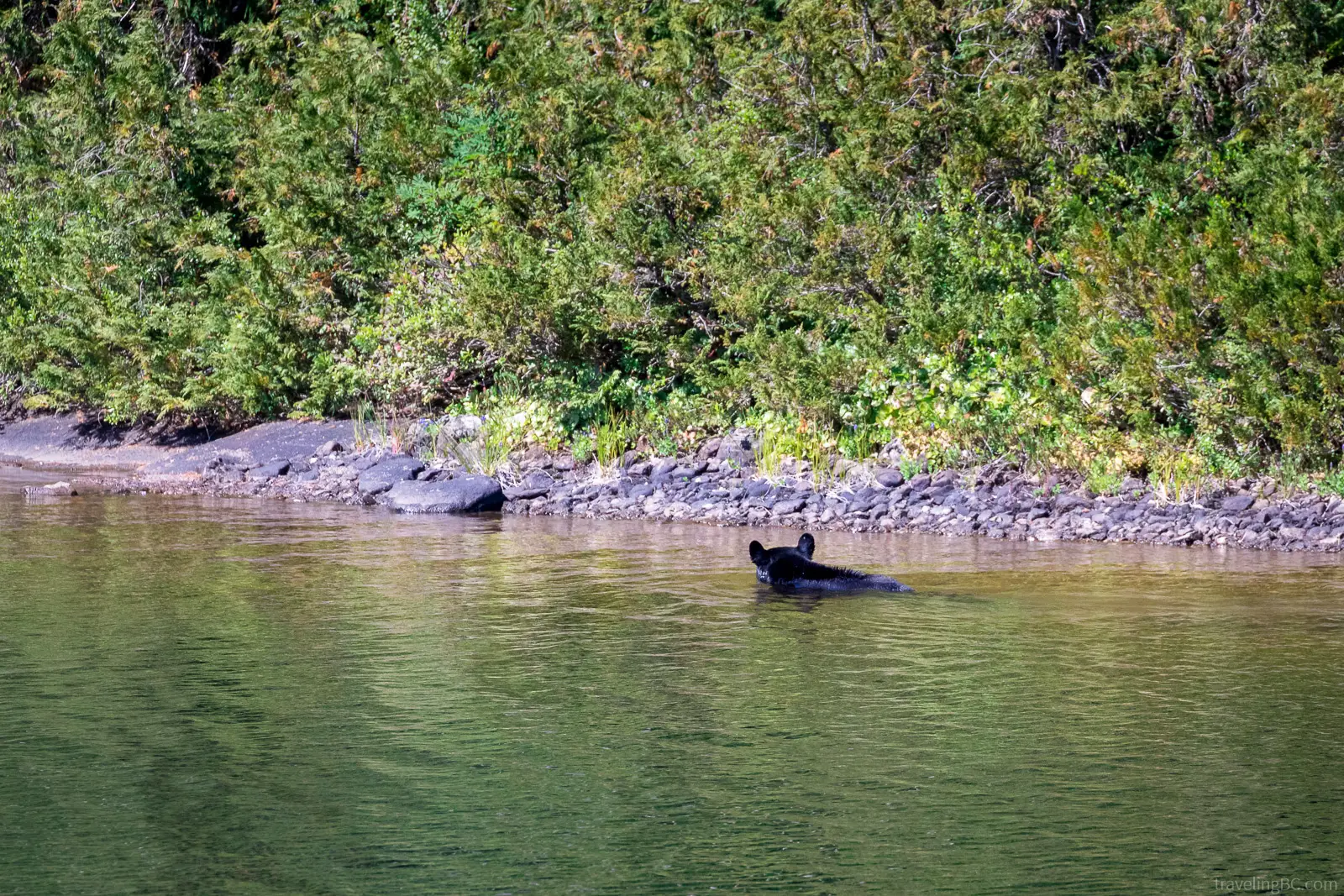
Wildlife in Strathcona Provincial Park
Black bears are common around Baby Bedwell and Bedwell Lake. If you are lucky, you might spot a bear swimming across one of the lakes on a hot day!
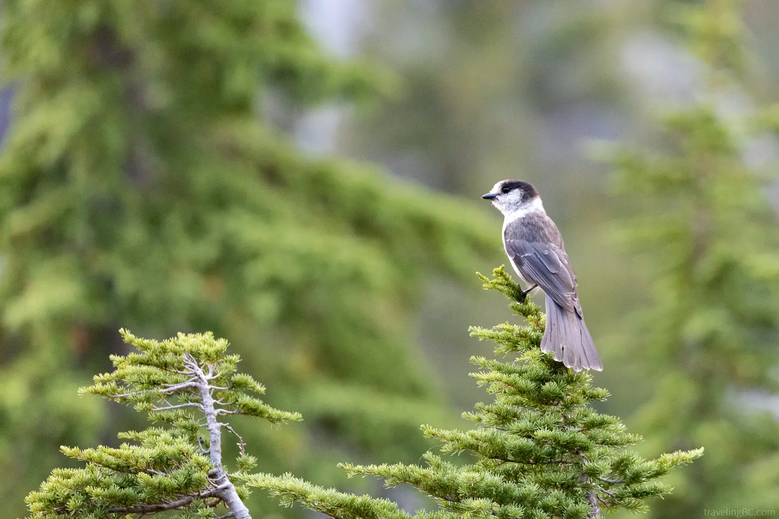
The Bedwell Lakes Trail is great for birdwatching. There are many different bird species in the area, including thrushes, hummingbirds, crossbills, grouse, and our personal favorite, grey jays (also known as Whiskey Jacks or Canada Jays).
If you check the small ponds near the boardwalks, you might spot a rough-skinned newt. Also, there are frogs and toads in the area, like Western toads and Northern Pacific Tree frogs. Their croaking might wake you up at night!
Other Attractions Nearby the Bedwell Lakes
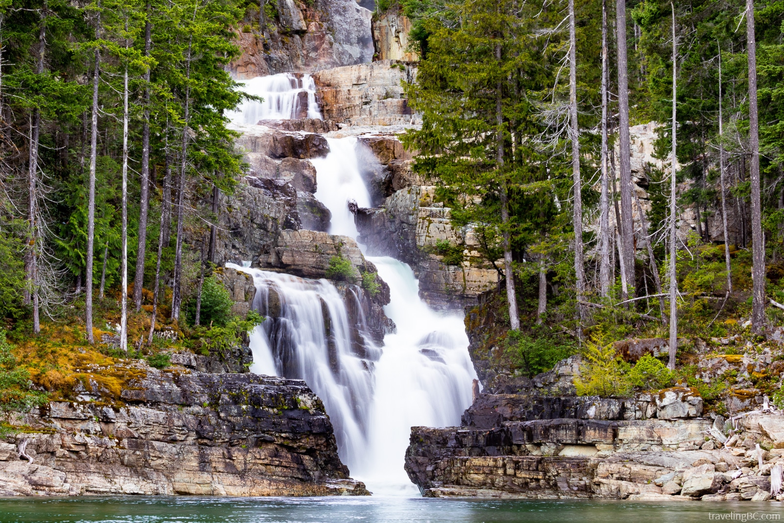
On Highway 28, only a couple kilometers outside of Campbell River, you will pass by Elk Falls Provincial Park. Elk Falls is a beautiful waterfall on the Campbell River, viewed from a suspension bridge across the river. Only a 30-minute hike round trip, it’s worth stopping on your way to the Bedwell Lakes to check out this impressive waterfall!
If you drive a short distance past Jim Mitchell Lake Road, you will find the turn-off to lower Myra Falls. Here, you can walk the easy 1.3 km loop to view the stunning Myra Falls. If you follow the trail down to Buttle Lake, there is also a pebble beach where you can swim near the waterfall!
Conclusions
The Bedwell Lakes Trail is a stellar hike, with awesome views of the mountains and a series of stunning subalpine lakes. You won’t regret spending your weekend exploring this area and its many lakes!
Top Travel Tips & Resources for BC
- Travel Insurance – If you’re travelling internationally, travel insurance is a must for any trip. Being covered by insurance is especially important when you’re going to an adventure-filled place like British Columbia. If you injure yourself while adventuring, you want to have insurance! We recommend using SafetyWing for international travel insurance. They are affordable and have great policies for travellers, digital nomads, and remote workers. Also, SafetyWing provides COVID-19 coverage, which many other insurance companies don’t cover.
- Car Rental – We find the best deal on vehicle rental prices using RentalCars.com. They compare the prices for different car rental companies so you can find the best deals out there!
- Accommodations – We prefer booking all of our hotels, hostels, and other accommodations through Booking.com because they have a flexible cancellation policy. Also, there are lots of different options on their platform, from hotels to vacation homes. Alternatively, Expedia and Hotels.com are good for booking accommodations. For vacation home rentals, VRBO is an excellent choice (they have lower fees than Airbnb, many of the same properties, and are more ethical).
- Flights – You can find many good flight deals on Google Flights or Kayak. If you fly at less popular times (e.g. mid-week or red-eye flights), you can save some money.
- Tours – Get the most out of your vacation by taking a guided tour! This is a great way to see the city, adventure to exciting new locations, and learn about the local culture. Viator or GetYourGuide are great options for booking tours.
